A new route through the York Central development has now opened. This route replaces a section of Leeman Road, changing the access routes to the National Railway Museum from the south and city centre.
This new route affects all modes of transport. Please see below for detailed information on how to access the museum.
Access to the museum from the north via Kingsland Terrace is unchanged.
Visit our visual story page to see pictures of the museum route with text descriptions.
BY RAIL
The walk from York station to the museum is signposted. Follow this link to watch a video of the route.
- Turn left outside the front of the station
- Pass the Milner Hotel and turn left onto Station Rise
- Continue through the tunnel then cross the road, turn left and follow the signs along Hudson Boulevard
- Turn right at the crossing point, walk along Foundry Way, parallel to the visitor car park
- Go straight ahead and turn right towards the museum entrance
There is also a route to the museum via the station footbridge, although this is not suitable for wheelchairs or pushchairs. When taking this route, cross the street and join the above route by walking down Hudson Boulevard.
BY BUS OR COACH
The Service 59 Poppleton Bar Park and Ride bus continues to run on the new route 7 days a week in both directions. For more information, visit the First Group Park and Ride website.
The 10L service (Poppleton-Stamford Bridge) continues in both directions only during evenings. The number 19 bus services (Skelton-York) will go in one direction only.
While there is a designated National Railway Museum bus stop, we recommend leaving the bus at Cinder Street. This stop will be closer to our current entrance. From there if needed, cross the street and head along Hudson Boulevard, featuring planting and benches. Turn left when you reach Foundry Way and follow signage towards the main museum entrance.
BY BIKE
The route by bicycle runs parallel to the walking route, along a designated cycle path on Hudson Boulevard. When you reach the turning point follow the signs and turn right to cycle up Foundry Way. Sheltered bicycle racks are available at the museum. Bikes are left at the owner’s risk.
ON FOOT
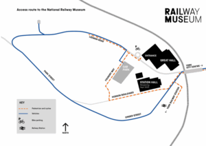
The new route to the museum from town is walkable and follows the new Hudson Boulevard and Foundry Way as shown in the map above. Please see the by rail section for more details on the walk from the station. When walking to the museum from town follow the same instructions, starting at the Marble arch pedestrian tunnel. The route from there is 713 meters long and is signposted.
BY CAR
The new route along Cinder Street and Park Street is signposted and joins up with Leeman Road from the northern end. Follow the route and go straight across the intersection to drive down Leeman Road towards the museum.
PARKING
The museum’s visitor car park is located on Leeman Road, a short walk away from the main entrance on the opposite side of the road. There is a traffic island to assist you in crossing Leeman Road.
Car parking costs £10 per day and can be purchased from inside the museum. The car park closes at 18:30.
Accessible parking for blue badge holders is free and is located in the main car park. The distance from the blue badge spaces to the museum entrance is approximately 200m.
Please be aware the museum’s car park offers limited parking and can often reach capacity by 11:00 during weekends and holiday periods.
Other long stay car parks can be viewed here. Alternatively, there are several Park and Ride services available to use.
We do not currently offer charging points for electric vehicles.
MAP